Thursday, June 30, 2011

Oases of the Great Sand Sea


 Hotels in Egypt and Lybia


The Great Sand Sea is an uninhabitable belt of shifting golden dune ridges up to 100 m (330ft) high, a natural impassable barrier between Egypt and Lybia up to 300 km (200 mi) wide and extending for some 600 km (375 mi) north to south. Human habitation is only possible in the five remote oases at its edge, where mineral springs and waterholes enable life. On this 1000 km (600 mi) road adventure, you will experience the magical stillness of elemental landscapes and wonder at the resilience of communities who have managed to preserve their culture, continuosly since antiquity, in the face of such overwhelmingly hostile odds.


Siwa, Egypt's westernmost oasis is the site of the ancient Oracle of Amun, consulted by Alexander the Great. It is an 80 km (50mi) swathe of date palms, olive trees and salt lakes inhabited by Berbers. The 400 km (250 mi) road along the ancient caravan route to Bahariya, you cross the surreal White Desert with dramatic rock formations like giant mushrooms, to reach Farafra, one of the most isolated places in Egypt.


Compared to this tiny oasis, Dakhla seems huge - fourteen villages surrounded by fields of mulberry, citrus, datepalm and fig, voerlooked by magnificent pinkish cliffs. It is perhaps the most beautiful stop on your journey and the village of Al-Qasr with its medieval architecture is one of the most significant archeological sites of Egypt's Western Desert. Your final stop is Kharga on the notorious Forty Days Road, the slave route from the Sudan to Cairo. Once back in the tourist maelstrom of modern Egypt, you will immediately yearn to return to the mystical desert silence.


HOW
By 4X4

WHEN TO GO
October to March

TIME IT TAKES
One to two weeks

HIGHLIGHTS
Shali Fortress, Siwa
Gebel al - Mawta - Mountain of the Dead, tombs cut into hillside.
Painted houses of Farafra.
Agabat Valley and Crystal Mountain in the White Desert.
Necropolis of Bagawat, Kharga - 2nd century Coptic tombs.

YOU SHOULD KNOW
This journeys can only be done in a 4X4 vehicle. You must obtain permision to travel between Siwa and Bahariya. A permit can be obtained on the spot in Siwa.

North Mayo Drive


Hotels in Mayo County
  
Drama underpins everything about North Mayo, whether it's the rugged landscape or its often-troubled history. Although only a few hours drive from Dublin or Belfast, it feels light-years removed from them. The area's population is now lower than it was before the potato famine and those who remain are among the hardiest and most welcoming people to be found anywhere.
The 173km (108 mi) North Mayo Drive takes you in a loop that starts and finishes in the county's largest town, Ballina. A choice of over fifty hostelries awaits you and good simple food is prepared in most of them. The drive, in essence, links ten communities, each with its own ditinct feel. In between there is ample opportunity to visit magnificent abbeys or simply wander along any one of many riverside trails.


Driving counter-clockwise, the road hugs the Atlantic coast before turning inlanf at Belderrig. From there it travels alongside the picturesque Carrowmore Lough, a perfect place to pull over and have a picnic. As the road swings round and you start the journey back towards Ballina, the peaks of the Nephin Beg Range dominate the landscape and the charming town of Bangor Erris demands that you stop and dwell a while. For those wishing to engage in more rugged outdoor pursuits, a well-appointed hiking trail leads off to the mountains.


This drive is a must for anyone who wants to experience the real Ireland. Around every corner there are symbols of martyrdorm and sainthood, of suffering and triumph. It is a land of desolate beauty, where the pace is gentle and the Craic is at its most genuine.


HOW
By car

WHEN TO GO
Year round, but the weather is best from March to October.

TIME IT TAKES
Three hours without stopping, but best enjoyed as a 2 or 3 day jaunt.

HIGHLIGHTS
The archaeological site of the Ceide Fields.
The glistening Lough Conn.
Rathfran Abbey - one among many.
The stretch around Lackan Bay and Downpatrick Head.

YOU SHOULD KNOW
Be prepared to be slowed down by agricultural activity on your way - be patient and remember that the gentler pace of life is part of the reason this area is so special.
 

North Holland's Historic Triangle

Hotels in North Holland


The "Historic Triangle" in Noord Holland consists of three small but charming former posts - Hoorn, Medemblik and Enkhuizen. Once fronting the Zuiderzee, since 1932 they have been contained withing the freshwater Ijsselmeer, the largest lake in western Europe. This area due north of Amsterdam not only offers classic Dutch landscapes of dykes and patchwork fields, but alsowell-preserved historic towns and villages that grew wealthy in the 17th century as the Dutch East India Company thrived. As always, wealth translated into fine architecture, and there are many splendid buildings from that opulent colonial era to admire.


The classic way of seeing these three is by taking the steam train from Hoorn to Medemblik. With lots of stops and starts for crossings, the preserved "steam tram" as the Dutch describe narrow-gauge railways, resplendent in original 1920s livery, chugs and whistles through the countryside, past incurious sheep and cattle and restored stations to Medemblik, complete with period extras that make it perfectly possible to imagine the reality of travelling this delighful line in its heyday.


From there, a steamer takes you on to Enkhuizen from whence the "Historic Triangle" can be completed by returning to Hoorn by scheduled train service. It is possible to book combined tickets for the train and steamer legs of the trip, with a "hop on, hop off" option that allows ample opportunity to explore. But do consult a timetable before attempting to undertake this rewarding journey to be sure you won't be disappointed. The steam train doesn't run between December and February, and there is a limited service only in March, October and November. The train does not always operate on Mondays, so a little pre-planning is required.


HOW
By train and boat

WHEN TO GO
April to September

TIME IT TAKES
Hoorn to Medemblik by steam train takes an hour (or 15 minutes more with the intermediate stop at Twisk).
Medemblik to Enkhuizen by boat is around 75 minutes.

HIGHLIGHTS
The steam museum in Hoorn - for a splendid collection of vintage locomotives, rolling stock and bygone railway artefacts.
Impressive former Dutch East India Company building in Hoorn and Enkhuizen.
Zuiderzeemuseum in Enkhuizen - reached only by water, this is an atmospheric recreation of a working fishing village from the past.

YOU SHOULD KNOW
Hoorn is just 30 minutes from Amsterdam by thoroughly modern double - decker train.
 

Highway 901 (La Ruta Panoramica)

Hotels in Puerto Rico


At the eastern end of Puerto Rico’s Ruta Panoramica, in downtown Yabucoa, the major road ends, and a narrow country lane winds straight ahead into the rising hills. Highway 901 is a slideshow, a scenic corniche road that has so far escaped the horrifying urbanization and development of Puerto Rico’s fabulous coastline.
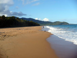
From Yabucoa it leads straight to the sea at Playa Lucia, a bedraggled but lovely palm-lined beach kept free of crowds by frankly dangerous currents.


Highway 901 climbs quickly past the beach, rising to the very cliff edge some 100 m (328 ft) high above the Caribebean, curling round the tail of the Cuchilla de Panduras Mountains as they drop into the sea. From here, you get a glorious view along the to of the cliffs: with a classic white lighthouse drawing your eye to the distance. Driving is hair - raising enough without going fast, because at several points the edge of the road is the edge of the drop. The view is the compensation for frazzled nerves.


The lighthouse is not open to the public, but you can stop outside it to admire the vistas either side of Punta Tuna, on which it stands. Below the rocky promontory, on both sides sandy coves are hemmed in with thick vegetation bursting with colourful flowers, their scent on the air. In crowded Puerto Rico, the breezy solitude is pure balm for the soul: it’s usually impossible to resist a scramble down to the beach itself before driving on. Above you, 901 swings back inland to join the roar of traffic at Maunabo, forming the norteastes boundary to the Punta Tuna wetland area of freshwater swamp and three kinds of mangrove. Like Highway 901, the reserve is tiny, beautiful, and a wonderful reminder that Puerto Rico’s coast isn’t all freeways and billboards.


HOW
By car

WHEN TO GO
November to June

TIME IT TAKES
One hour, although the road is only 15 km (9.3 mi). Everybody stops to admire the view.

HIGHLIGHTS
Leaving the freeway (full of traffic to and from the biggest naval base in the western hemisphere, 30 km north at Washington Roads).
The Punta Tuna west beach, protected from development so that light pollution does not distract hatching leatherback and hawksbill turtles, for which it is na important site.
The wetlands and mangrove forest, rare in Puerto Rico where backfill practices are common. Here the forest further protects turtles from human encroachment.
The romance of a sub-tropical cornice, the wind and the sun.

YOU SHOULD KNOW
1- The roadside trees chosen for their shade-providing properties are called “flamboyants”
2- Puerto Rican authorities are extending the freeway straight through the middle of Highway 901’s scenic wonders.
Hotels in Puerto Rico

Icefields Parkway

Hotels in Lake Louise


The magnificence of the Icefields Parkway (Hwy 93) can scarcely be overstated - a 230 km (144 mi) road from Lake Louise to Jasper through th heart of the Rockies, it ranks as one of the world's ultimate drives. Its seemingly unending sucession of enormous peaks, vast glaciers, iridescent lakes, wild-flower meadows, wildlife and forests - capped by the sheer majesty of the Columbia Icefield - is utterly overwhelming.
Fur traders and First Nations peoples dubbed it the Wonder Trail, though the current road owes much to the depression era works programme and it was only opened in 1940 in its present incarnation.


Leaving the iconic image of Lake Louise behing you, the first 40 kn (25mi) of the road climbs steadly north through forest, until you reach the alpine meadow at Bow Summit, the journey's highest point. The next section, which drops down to the Saskatchewan River, offers the best chance to see black bears and moose. The Crossing marks the transition from the jaw-droppingly good to the truly awesome. This 50 km (31 mi) section is famous the world over for its breathtaking scenary as Mount Athabasca and the Columbia Glacier heave into view.


Mountain goats, bighorn sheep and elk are common along the final 100 km (62 mi) of the Parkway. The road ascends Tangle Ridge, then drops down through forest and follows the Sunwapta and Athabasca Rivers into the charming little town of Jasper. The outstanding features of this final leg of the journey are the Sunwapta and Athabasca Falls and the opportunity to spot grizzly bears and mountain caribou.
Although over a million people make the trip each year to experience this "window on the wilderness", the sheer vastness of the landscape still means it can rarely seem crowded.


HOW
By car

DEPART
Lake Louise, AB

WHEN TO GO
May to September offers the best weather.

TIME IT TAKES
Around four hours without stopping, but allow a full day of picnic breaks.

HIGHLIGHTS
The Columbia Icefield - a chance to witness a pristine wilderness.
Lake Louise - with its turquoise lake and overhanging glacier.
The Crossings - a chance to reflect and antipate.
Arriving in Jasper, a rather special town set on a small plateau surrounded by a spectacular panoramic mountain backrop.

YOU SHOULD KNOW
Even in good weather the sheer elevation of this highway can mean that road conditions can change rapidly, so come prepared for all eventualities.

Garden Route

Hotels in Garden Route


South Africa’s Garden Route is a spectacular road trip along the coast from Mossel Bay east to Storms River. Sandwiched between the Outeniqua and Tsitsikamma mountains and the Indian Ocean, the road is named not for its floral gardens but because of its lush and varied vegetation, so different from the country’s harsh, dry interior.


From Mossel Bay, na old-fashioned seaside town, the N2 links a series of charming towns, with areas of great natural beauty in between. This is part of the Cape Floral Region, named a UNESCO World Heritage Site in 2004. It is famed for its fymbos, natural heathland vegetation that includes 9000 species, 6200 of which endemic. Of these, many are flowering and others are fragrant. Rooibos and honeybush are both commercially harvested, and one of the many proteas, Protea cymaroides, is South Africa’s national flower.
Pass through the Wilderness National Park - its lagoons and wetland are home to 250 species of bird, including Knysna Lourie, a bright green bird with red wings, and many kingfishers.


If you like oysters, you can feast on them here to your heart’s content, and of course the local wines are excellent. From Plettenberg Bay, another seaside resort, the road descends sharply, winding through old growth forest until it reaches the finest stretch of untamed coastline in Tsitsikamma National Park, before reaching the journey’s end at Storms River.
Along the way there is much to do, hiking, diving, kayaking or even playing golf. Keep an eye open for the very rare Knysna elephants - a handful are said to roam the magnificent yellowwods between Knysna and Plettenberg. Perhaps you’d like to travel on the last continuosly operating steam train on the continent, the steam train Choo Tjoe, currently running only between Mossel Bay and George, after mud slides in 2006 damaged the track.


HOW
By car

WHEN TO GO
November to May

TIME IT TAKES
It is possible to drive in a day, but to enjoy and appreciate this trip you should spend several days, up to a week.

HIGHLIGHTS
Watch the endangered southern right whales in their calving grounds, November and December.
Go cage diving with great white sharks at Gansbaii.
Cable slide across the rainforest canopy in Tsitsikamma.
Visit an ostrich farm at Oudtshoorn.

YOU SHOULD KNOW

The Garden Route and the Wine Route are sufficiently cloe together to move easily between the two. If this is your plan, give yourself a few extra days.
 

Tuesday, June 28, 2011

Cross the Atlantic on a Cargo Boat


Hotels in New York City


In a post-modern age of counting carbon footprints, freighter-travel is about as eco-friendly as it gets, short of a rowing boat. Cargo ships are the life-line of the global economy, transporting containers of goods all over the world. Although they do carry passengers, freighters don't advertise themselves. To book a passage you must be prepared to do plenty of research and be dedicated to the idea of a cryptic adventure into the unknown.
Of all the trade routes, the Trans-atlantic crossing is perhaps the most romantic, harking back to the belle époque, era of the ocean liner. The prospect of crossing the bleak immensity of the Atlantic without any organized on-board entertainment may seem a challenging one, but if you are self-reliant yet congenial then a freighter is the ideal way to travel. There is enormous pleasure to be had in wandering between decks, mucking in with the crew, or just sitting outside your cabin reading Moby Dick.


On the voyage to New York from Tilburg, London's container port, there comes a point, after the ship has weighed anchor at Rotterdam and Le Havre and there is only ocean ahead, when you may fleetingly feel stir-crazy; until the mesmerizing effect of the sea suddenly makes you aware of your own insignificance in comparison to the immensity of nature and you start to experience a joyful sense of liberation from mundane responsabilities.


After days of nothing but sea and sky, the sight of the Statue of Liberty is both elevating and humbling. As you step down the gangplank into the Land of the Free, you cannot help sparing a thought for the countless numbers who made this crossing before you, at the same time as wondering how anyone could possibly be so foolhardy as to attempt it in a rowing boat.


YOU SHOULD KNOW
Freighters carry a maximum of 12 paying passengers and sail to virtually every destination in the world at less than half cost of a passenger liner. A certain amount of serendipity is involved in planning your trip since there aren't regular scheduled crossings as there are with passenger ships. Sailing dates as well as ports of embarkation and debarkation may suddenly change without notice. It is important to keep in mind that you are on a working ship and it is not part of the crew's job to entertain or serve you.